703 Rock'n'Roll: Sektion 3


Details
Responsible for this content Graubünden Ferien.
Please note: from 10. until and including 27. June, the facilities in the indoor pool building will be closed for the annual maintenance works. Sauna and gym will reopen on 21. June.
Additional infos. Responsible for this content Graubünden Ferien.
Responsible for this content Graubünden Ferien.
Responsible for this content Graubünden Ferien.
Responsible for this content Graubünden Ferien.
Show all 8 images
Untervaz has a public transport connection with Chur every half hour and can be easily reached by car. The hike starts in the middle of the village (stop Untervaz Dorf) and leads via Vordergasse to the turn-off to the various Alps. We follow the signpost to the left in the direction of Fallboden and Hinteralp. At the Fallboden, turn left again through the forest to the Bärenhag. On the way we pass two short tunnels carved into the rock.
The alpine road from Bärenhag to the former Walser settlement of Batänja is a bit steep, but easy to walk. On Batänja (belonging to the municipality of Haldenstein) it is worth taking a break and taking in the view of the opposite mountains of the Rhine Valley. Unfortunately, there is no place to stop for refreshments.
The path now winds its way through the small settlement and on through forest and across meadows to the highest point of the hike on the Gürgütschboden. Now it goes downhill on the alpine path. Again and again there are wonderful views of the valley and the rock formations of the Rätikon. The last section from Fallboden back to the village is identical to the ascent route. Right next to the village square you will find the Linde restaurant, where you can wait comfortably for the next post bus.
Responsible for this content Graubünden Ferien.
This content has been translated automatically.
Show all 7 images
The hike through the vineyards and forests of the Five Villages into the Bündner Herrschaft begins at the northern end of the village at the "Gargällis" bus stop. Cross the access road to the village in a northerly direction and follow the sign for Molinära. After the Molinera, the path climbs slightly along the edge of the forest.
After another ascent to Dunkel Töbeli and over the Chessirüfi, you are already in the municipality of Landquart. At Birchholz there is a beautiful view of the village of Igis and the Rhine valley. It is worth stopping over the former moated castle of Marschlin. In slight ups and downs, the route continues to the Ganda, where it crosses under the Prättigauerstrasse.
After the passage at the tennis court, cross the river Landquart and walk along the right bank. After about 1 kilometre, leave the dam and head over the hay divider towards Malans station.
Responsible for this content Graubünden Ferien.
This content has been translated automatically.
Show all 8 images
Obersays can be easily reached by public transport, with four daily Postbus journeys making this possible. However, the trip must be booked by phone at least 1 hour before departure. The well-developed road also allows you to travel by private car. Right next to the post bus stop is an overview map of the area around the former Walser settlement of Stams. On the forest and alpine path we leave Obersays. At the Zazaschgrank car park we take the path in the direction of Spundätscha. At the end of the forest, the now narrow road leads to the left and quite steeply up across meadows to the Maiensäss Spundätscha.
The route continues between the houses and on the open pasture land in the direction of Zanutscher Boden. On the ascent, it's worth taking a look back from time to time. The view towards the Graubünden Oberland is becoming more and more fantastic. At the highest point of the hike at the Zanutscher Boden you can see the Dolomites of the Rätikon with the well-known peaks Falknis, Schesaplana, Drusenfluh and Sulzfluh.
This is followed by the descent over pastures and through the alder forest down to the former Walser village of Stams. The small mountain restaurant (open every day from the beginning of May to the end of October) invites you to linger and enjoy. At the Artimi viewpoint there is a special wooden monument in memory of the Poles interned here (1942 - 1944). Always following the alpine road, you will soon reach the starting point in Obersays.
Responsible for this content Graubünden Ferien.
This content has been translated automatically.
Show all 3 images
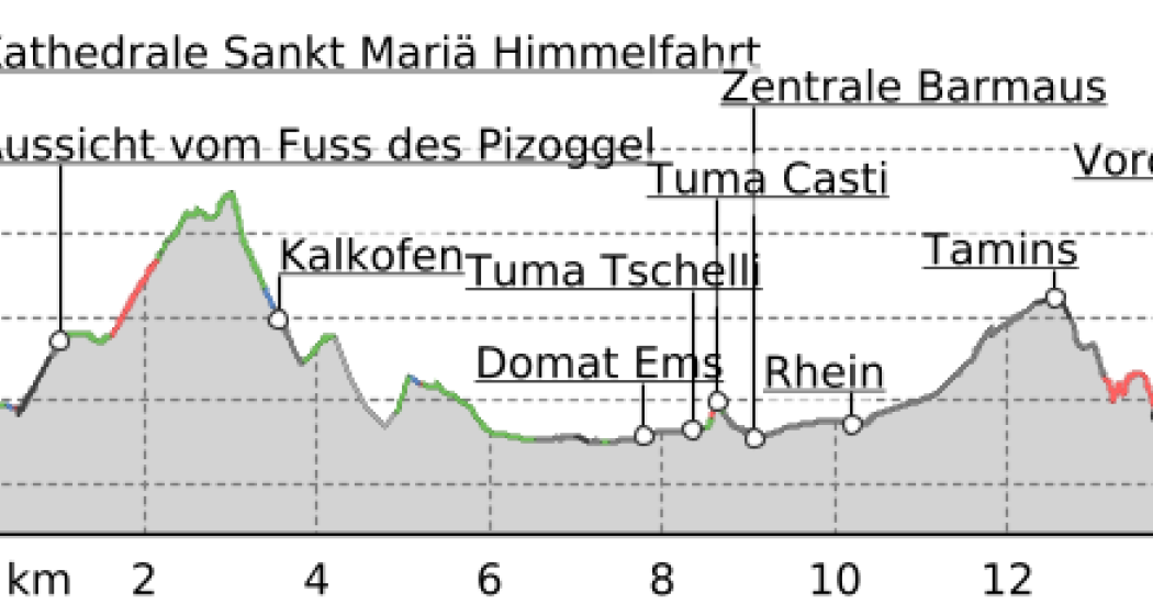
There are now two pilgrimage routes between Chur and Disentis, with the Via Francisca running mainly on the southern side of the Rhine, while the Way of St. James Graubünden, called Via SonGiachen, runs on the northern side. However, the two paths are almost identical up to Tamins. So it may happen that the two hikers in front are also pilgrims, but on their way from South Tyrol to Central Switzerland.
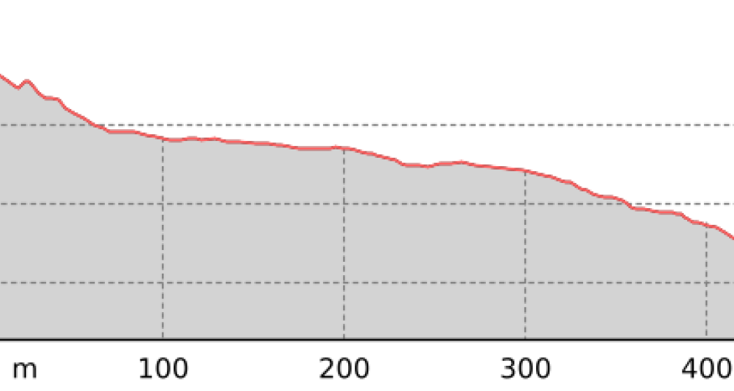
Both paths lead from Chur towards the Graubünden Oberland, called Surselva. Initially, we hike along the southern edge of the wide Rhine valley. At Domat/Ems we first cross the tracks of the Rhaetian Railway at the station, then walk between the two hills "Tuma Tschelli" and "Tuma Casti" and then circle the second to the north. This brings us first to the Rhine power plant, and after crossing the Rhine over the weir, the paths then separate to meet again briefly on the main square of Tamins. But only as far as crossing the village square, where we separate again. Now it's down to cross the Vorderrhein on the railway bridge. And so we arrive at Bonaduz.
The stages in this documentation are suggestions that each pilgrim can adapt to his wishes. however, the technical data always concern the assumption that these stages are completed in one day.
.
Normal hiking/trekking equipment: backpack with rain cover, well-worn footwear, durable clothing appropriate to the season, rain and sun protection, hiking stick or trekking poles, pilgrim's passport.
Chur - River Plessur - Rose Hill - Lime kiln - Paleu sura - Domat/Ems - Tuma Casté - Power plant - Rhine weir - Tamins - Anterior Rhine - Campagna - Bonaduz
SBB, RhB
A 13
Responsible for this content Graubünden Ferien.
This content has been translated automatically.
Show all 8 images
Your journey starts in Chur where you’ll discover the rolling hills of the Domleschg fruit and castle country. The Glaspass is an insider tip that will take you to the Beverin Nature Park. The slope is long, but not too steep. A beautiful panorama tour takes you over the Heinzenberg back to the historic trading town of Thusis. The journey continues through the natural monument of Viamala Gorge, where 300-meter high cliffs will have you in awe. The route to Andeer leads through the villages of Schamserberg, which tower high above the valley and score points for their panoramic views. The route climbs up towards Lai da Vons. Here you’ll be able to enjoy the tranquility of nature and an epic panorama. You can ride down the hill until you reach Sufers, and through the valley floor of the Rheinwald you’ll reach Splügen, Graubünden's oldest pass village. From Medels via Nufenen and Posterior Rhine you’ll continue following the young Rhine towards its source. On the other side of the Rhine, the route leads down into the valley again and you’ll ride through the idyllic landscape passing the Posterior Rhine through the valley floor of the Rheinwald back to Splügen. The ascent through the Fugscht forest is short but steep. A rapid descent brings you to Sufnersee and on the Northern shore; you ride along a little-used road towards Roflaschlucht (gorge), which guarantees breathtaking views into a wild gorge. Via Bärenburg and Pignia, the route leads to Zillis, where the Capuns Swiss champion invites you to lunch at the hotel Post. Via Reischen you ride through the Viamala to Thusis and along the Posterior Rhine through the Domleschg. From Reichenau, where the Anterior Rhine and the Posterior Rhine merge, you have a comfortable ride back to Chur.
Stages
Stage 2: Thusis – Glaspass - Thusis
Tip: Don’t worry about carrying your luggage on this trip multi-day trip. Book the luggage transfer from hotel to hotel - convenient and easy.
You start the journey in Chur (593 m above sea level) and get on bike path no. 6 on the Polenweg to the imposing fortification Porta Rhaetica. From Rothenbrunnen the route makes its way over the gentle hills of the Domleschg fruit and castle country. In Paspels (757 m above sea level), you can marvel at the art works by the well-known artist Robert Indermaur. Lake Canova invites you to take a break, especially to cool down during summer. From here, it’s not far to Thusis, the historical trading place (680 m above sea level).
Thusis - Glaspass - Thusis: 36.1 kilometers - 1659 altitude
The Glaspass is an insider tip. The MTB route no. 90 takes you from Thusis (680 m above sea level) past the villages of Urmein and Tschappina into the Beverin nature park. The ascent to the Glaspass (1846 m above sea level) is long, but in addition to steep ramps, there are always flat roads where you can relax a little. Once you arrive at the pass, it’s worthwhile to ride a few meters further to the Beverin mountain inn. You definitely deserve to take a little break here! You only follow the road down the valley for a little while longer now, and then turn onto MTB route no. 623 "Heinzenberger Maiensäss Route". This will lead you high above the Domleschg over an impressive panoramic path. From Obergmeind (1813 m above sea level) via Plau to Prau da l'Alp, you’ll encounter several short steep slopes, but the great view makes up for it. The rapid descent to Präz (1170 m above sea level) and Raschlegnas will definitely put a smile on your face. The trail leads you through Cruttis Tobel and Tartar back to Thusis (680 m above sea level).
Thusis - Andeer: 27.1 kilometers - 983 altitude
From Thusis (680 m above sea level), the old Viamala road leads through the "lost hole" to Rongellen. The 300-meter high cliffs of the Viamala Gorge natural monument will amaze you. The road runs high over the Viamala and looking into the gorge is worth it. A stop at the Visitor Center not only gives you a chance to rest, but also brings you closer to the AlpTransit’s history. The route continues in the direction of the Muntogna da Schons and Schamserberg villages. Through Zillis (945 m above sea level) and Donat you’ll reach Lohn (1585 m above sea level), Mathon and Wergenstein. A great view over the whole valley, including the fantastic road to Wergenstein, which towers high above the Schamsertal will be your reward. A nice descent on an agricultural road brings you to Casti. An imposing wooden bridge takes you to Clugin, before you start the last stretch of the journey riding on a dirt road to Andeer (982 m above sea level). Andeer is known for its healing spring. Enjoy the mineral bath with a wellness area – it’s a guaranteed rest for your sore muscles.
Andeer - Lai da Vons - Splügen: 22 kilometers - 1237 altitude
The road from Andeer (982 m above sea level) in the direction of Lai da Vons ascends without mercy. As you climb higher and higher through the forest of the Tranter Tschaingel, you’ll get to enjoy wonderful views over the whole valley. At Pastgaglia, you have almost already climbed up one thousand meters and will leave the tree line behind you. There will hardly be any flat roads to offer a chance to take a breath. You do have to persevere for a bit. Turn left once you reach Larisch. The natural road is now a bit bumpy. Shortly after the highest point of the climb (2050 m above sea level), you’ll be able to see the Lai da Vons (1994 m above sea level). In the tranquility of nature, enjoy the epic panorama, pat yourself on the back and roll down the mountain to Sufer's. The cycle route no. 505 "Rheinwaldroute" takes you through the valley floor of the Rheinwald to Splügen (1458 m above sea level), the oldest pass village in Graubünden.
Splügen - Splügen: 33.2 kilometers - 361 altitude
From Splügen (1458 m above sea level) follow the Rhine towards its source. Via Medels and Nufenen you’ll ride through the Rheinwald to the Posterior Rhine (1620 m above sea level), the oldest Walser settlement in Graubünden. From the Posterior Rhine it’s not far to the shooting range. During the week, the trip ends here, but on the weekends, you can reach the valley via a natural road in the direction of the Rheinquellhorn. On the other side of the Rhine, the route leads down the valley on a dirt road. Via the old Landbrugg, you’ll return to the village Posterior Rhine. If you like taking the easy path, take bicycle route no. 6 to Nufenen. Riders who are interested in a more technical road should tackle the meadow path on the other side of the Rhine. From Nufenen the cycle route no. 505 "Rheinwaldroute" leads down into the valley. You’ll make your way back to Splügen (1458 m above sea level) while riding along the Posterior Rhine through the valley floor of the Rheinwald.
Splügen - Chur: 58.6 kilometers - 580 altitude
You’ll leave Splügen (1458 m above sea level) on cycle route no. 505 "Rheinwaldroute" down the valley. At first, the road heads a few meters in the direction of Splügen Pass.
In the first bend, you’ll turn left and reach a short but steep climb through the Fugscht forest (1589 m above sea level). A rapid descent brings you to the Sufnersee, whose water shines turquoise. On the Northern shore of the lake, you’ll take the little-traveled road in the direction of Roflaschlucht (gorge). Even from the road, you’re guaranteed great views of the wild canyon. Through Bärenburg (1040 m above sea level), you’ll take a side road to Pignia. From here, a nature trail leads to Zillis (945 m above sea level). An insider's tip is Capun's, a local specialty - prepared by the Swiss Capuns champion at the hotel Post. Strengthened from the food the route leads you over Reischen (1024 meters) through the Viamala gorge to Thusis (680 m above sea level). Cycle route no. 6 takes you along the Posterior Rhine through the Domleschg. In Reichenau, where the Anterior Rhine merges the Rhine Anterior, change onto the Rheinrad route no. 2 and a comfortable ride back to Chur (593 m above sea level).
Responsible for this content Graubünden Ferien.
This content has been translated automatically.
Show all 3 images
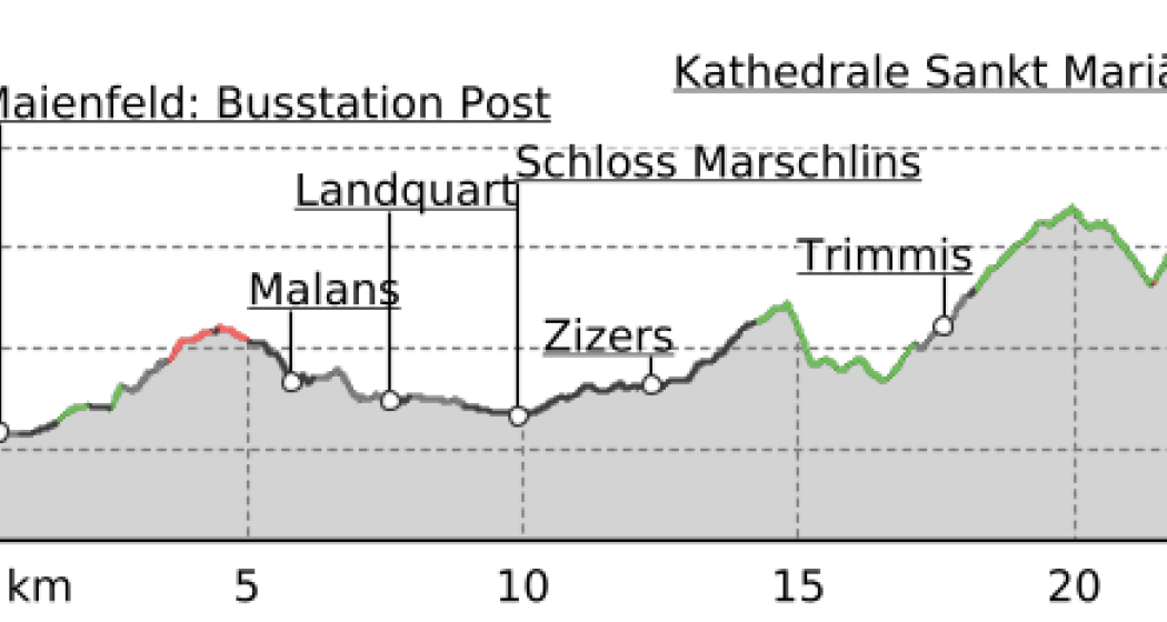
After leaving Maienfeld, we walk through the vineyards of Jenins and Malans. After the village of Malans, we leave the "Graubünden dominion", as this wine-growing region is called.
Afterwards we cross the Landquart, which has left the Prättigau shortly before through a very narrow rock cut. In the upper part of this valley are the well-known ski resorts of Klosters and Davos.
We stay on the eastern side of the Rhine in the relatively wide valley to Trimmis, passing through other, smaller vine-growing areas. The Rhine Valley is now gradually changing direction to the west.
Leaving Trimmis, we then go up again to the valley flank, which brings us shade in the forest and also gives us the opportunity to look at the Rhine Valley from the heights. In doing so, we also bypass the extensive outskirts of Chur, which lie at the bottom of the valley. This takes us through a lot of nature directly to the cathedral of Chur, the capital of the canton of Graubünden.
The stages in this documentation are suggestions that each pilgrim can adapt to his wishes. however, the technical data always concern the assumption that these stages are completed in one day.
.
Normal hiking/trekking equipment: backpack with rain cover, well-worn footwear, durable clothing appropriate to the season, rain and sun protection, hiking stick or trekking poles, pilgrim's passport.
Maienfeld - Eichholz - Erlenböden - Buochwald - Malans - River Landquart - Marschlins Castle - Igis - Zizers - Molinära - Trimmis - Bach Maschänser Rüfi - Fürstenwald - Waldhaus - Eulengut - Chur Cathedral
SBB
A13 / E43
Responsible for this content Graubünden Ferien.
This content has been translated automatically.


